Archive for category News
Update your AUXCOMM database Information
Valuable training links
Winlink RMS Express Youtube training videos by K4REF:
AUXFOG and NIFOG can be found here: Public Safety Tools
Online training for VIPER: NC Public Safety VIPER Radio
Communications Unit overview: Communications Unit Overview
FLDIGI / FLMSG training links
NBEMS Intro: http://www.arrl.org/files/file/On%20the%20Air/Tutorials/Introduction_to_NBEMS%202_1.pdf
NBEMS ADVANCED: http://www.arrl.org/files/file/On%20the%20Air/Tutorials/Advanced_NBEMS_3_0.pdf
YouTube configuration video: http://www.youtube.com/watch?v=2cAl3e0No70
New update on NC VIPER System Status
This is a link to the PDF document https://www.ncdps.gov/Index2.cfm?a=000001,001148,001154 .
Interesting timeline and financial constraints.
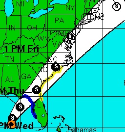
Tropical Storm Andrea
Tropical Storm Andrea formed in the Florida Gulf Coast just a few days into the 2013 hurricane season. As of this evening, models from the National Hurricane Center indicate Andrea will impact areas served by AUXCOMM late this week.
Interests along the US East Coast are urged to monitor NOAA Weather Radio, local weather forecast products, as well as the National Hurricane Center.
ARRL Attack on the NIMS/ICS/AUXCOMM Model
Excerpts from an ARRL presentation by Dan Henderson, N1ND, given at RARsfest on March 30, 2013. This presentation had nothing to do with Emergency Preparedness… unfortunately. Instead, Dan took this opportunity to repeatedly attack the NIMS/ICS training model and bark orders from ARRL HQ in Newington.
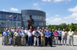
OEC AUXCOMM training class held at the N.C. State EOC
Amateur Radio is a hobby.
Emergency Communications is a commitment.
Click on photo for full size image.
NC: Hurricane Sandy Damage Reports
Attention North Carolina operators:
North Carolina Emergency Management (ESF6/Human Services) is interested in reports of damage caused by Hurricane Sandy. If you have personally witnessed significant damage (see below), please send the following information via email:
- Your name and callsign
- Address of damage.
- Description of damage.
Emergency Management is looking specifically for the following:
- Hazards
- Significant damage/collapsed structures
- Physical hazards
- Boats where sofas would normally be.
Please note this address is not monitored in real time and is not to be used to report an emergency. If you require emergency assistance, please dial 911.
Please send damage reports to: sandyreports@winlink.org. You must use the following Subject line:
//MARS R/ Hurricane Sandy Report
We will be collecting damage reports through 2359Z 10/30/2012.
New AUXCOMM computer-based training modules from OEC
DHS/OEC has developed and posted new AUXCOMM training modules that are specifically intended for the AUXCOMM community. The files, in several formats, can be found at http://www.publicsafetytools.info/training/start_auxcom_v1.php . Note the specific references to the AEC – Auxiliary Emergency Communicator. That is the resource type that the DHS Office of Emergency Communications has applied to us.
Hurricane Season is Upon Us
June 1st marks the “official” beginning of the 2012 Atlantic Hurricane Season. Now is a good time to assess and evaluate your levels of preparedness both personally and professionally to ensure that you are ready in the event of an emergency or deployment or evacuation event.
Do you have an emergency kit ready for your home and car? Does it include items for your pets? Do you have a plan for communicating and meeting with your family when cell phones and internet access are down?
Are your 24 hour pack and 7 day “go kit” packed and ready to go? Is your “go kit” really operational and ready for deployment in the event you are asked to mobilize and provide disaster communications? Have you tested it?
There are many excellent sources of preparedness information o the internet. Take some time and review. The National Hurricane Center offers hurricane status updates by email or SMS/Text. Sign up at http://www.nhc.noaa.gov/signup.shtml. As always, you can monitor http://www.nhc.noaa.gov/ for the latest official forecast graphics.

